
Last updated on .
Al-Shuhada Street is a major road in the Old City of Hebron, Palestine. It’s the main road leading to the Tomb of the Patriarchs and translates to Martyrs’ Street. The street is included in the UNESCO World Heritage listed Old City of Hebron.

Al-Shuhada Street
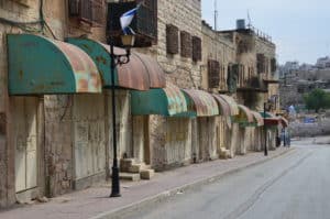
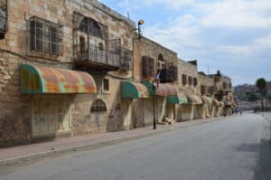
We walked down al-Shuhada Street after visiting the Avraham Avinu settlement with our guide, Eliyahu. The street, which is known as King David Street to Israelis, is a virtual ghost town.

After American-Israeli settler Baruch Goldstein (1956-1994) opened fire on Muslim worshippers at the Tomb of the Patriarchs on February 25, 1994, killing 29 and injuring 125, the Israeli government closed al-Shuhada Street to Palestinians and all Palestinian vehicle traffic.

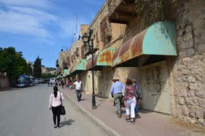
304 Palestinian shops and warehouses were shuttered along the street. For several years, Palestinian pedestrians were refused access to the entire street, and are still unable to enter some parts. Because of this, al-Shuhada Street has been nicknamed Apartheid Street.

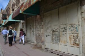

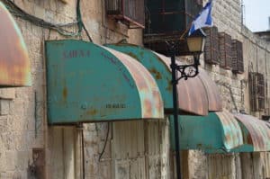

Building entrances along al-Shuhada street were completely welded shut, including entrances to homes. Homeowners living above the shops were forced to enter their homes by climbing through holes in the walls or through their roofs.


Al-Shuhada Street is the subject of frequent protests. Demonstrations call for the opening of the street and have been joined by Palestinians, Israelis, and international activists. There have been incidents of the Israeli army using rubber bullets and tear gas on the protesters.


Israeli settlers have also added street signs and interpretive panels in Hebrew and English along the street. Although illegal, they placed them there to assert their dominance over the Israeli part of the city.


Israeli Graffiti
An open section of the street features Israeli graffiti. Eliyahu deciphered some of it for us. Images on one door were meant to represent the different type of people living in and visiting Hebron.


Murals
Further down the street near the Beit Romano settlement is a collection of murals. We saw them in reverse order, but I’ll describe them in the correct order here. The first mural represents the Roots of the Jewish People. It describes Hebron in the biblical era as the “city of the Patriarchs and Matriarchs, capital of Judea, and the site of the onset of David’s reign”.

The second mural is titled A Pious Community. It states that from the 10th to 19th centuries, Hebron was “one of the four Holy Cities in the Land of Israel“, and a “community of Torah, charity, and kindness”.


The third mural is titled Destruction, and represents the 1929 riots: “Arab marauders slaughter Jews. The community is uprooted and destroyed.”


The fourth and final mural is titled Liberation, Return, Rebuilding. It represents the 1967 “liberation of Hebron and reestablishment of its Jewish community”.


End of the Road
From there, al-Shuhada Street continues past the Beit Romano and Beit Hadassah settlements. Shops are shuttered all the way to the end, where there’s a checkpoint to the Palestinian area of the city. The street leading uphill near the checkpoint takes you to the Tel Rumeida settlement.


